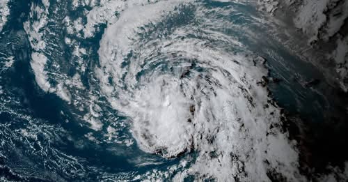
Tropical Storm Dolly Forms and Heads Toward the Eastern Caribbean — Heavy Rain and Flooding Threat Grows… See More
Tropical Storm Dolly formed over the central tropical Atlantic on Thursday, August 27, becoming the fourth named storm of the 2026 Atlantic hurricane season. The system is moving rapidly westward toward the Leeward Islands, prompting residents and officials across parts of the eastern Caribbean to closely monitor its progress.
According to the National Hurricane Center, Dolly initially had maximum sustained winds of about 40 mph and was traveling west at roughly 24 mph. At the time of its formation, the storm was more than 1,500 miles east of the Leeward Islands.
Although Dolly is not currently expected to become a major hurricane, meteorologists are warning that its effects could still be significant, particularly because of heavy rainfall.
The biggest concern may not be the storm’s winds.
It may be the water.
A Fast-Moving Storm
Dolly is moving unusually quickly across the Atlantic. Forecasters expect the storm to continue traveling westward over the next several days as a strong area of high pressure guides its movement.
The National Hurricane Center has indicated that Dolly could approach the Leeward Islands over the weekend. However, meteorologists also expect the storm to encounter increasingly unfavorable conditions.
Dry air, stronger wind shear and the storm’s rapid forward motion are expected to weaken its circulation. The National Hurricane Center has forecast that Dolly could lose its tropical-storm characteristics before or around the time it reaches the island chain.
That does not mean the threat disappears.
A weakening tropical system can still carry enormous amounts of moisture.
And when that moisture reaches mountainous islands, heavy rainfall can become dangerous very quickly.
Rain May Become the Biggest Threat
Forecasts indicate that rainfall associated with Dolly could begin affecting the Leeward Islands late Saturday into Sunday, followed by possible impacts in the Virgin Islands, Puerto Rico and Hispaniola Sunday and Monday.
The National Hurricane Center has warned that heavy rainfall could result in flash flooding, especially across areas of higher terrain.
That warning is particularly important for communities that have experienced flooding from previous tropical systems.
Even when winds remain below hurricane strength, several hours of intense rainfall can overwhelm drainage systems, flood roads, cause landslides and isolate communities.
Residents should therefore avoid judging the danger of Dolly solely by its wind speed.
A storm does not need to become a hurricane to cause serious disruption.
No Coastal Watches or Warnings Yet
As of the National Hurricane Center’s Thursday evening advisory, there were no coastal watches or warnings in effect for Dolly. The storm was still far offshore and had not yet reached the islands.
That could change as the storm gets closer.
Officials across the Caribbean are encouraging residents to continue monitoring forecasts rather than waiting until the last moment to prepare.
People living in vulnerable areas can use the time now to secure loose outdoor objects, clear drainage areas, check emergency supplies and review evacuation plans if they live in locations prone to flooding or landslides.
The Name Has Drawn Attention
There is another reason Tropical Storm Dolly has attracted unusual attention.
The storm formed only days after the death of country music legend Dolly Parton, creating an emotional coincidence that quickly spread across social media.
But the name of the storm was not chosen because of Parton’s death.
The National Hurricane Center has explained that the name Dolly was already part of the predetermined Atlantic tropical cyclone naming list. The timing is therefore entirely coincidental.
Storm names are selected in advance through an established international naming system. They are designed primarily to make warnings easier to communicate and remember.
So despite the emotional connection many people may make between the storm and the singer, there is no official tribute involved.
What Happens Next?
The next several days will be critical for determining exactly how much rain Dolly ultimately delivers.
At the moment, forecasters expect the system to weaken as it approaches the Caribbean. Increasing vertical wind shear and relatively dry air are expected to interfere with the storm’s organization.
But tropical weather can change quickly.
Small changes in atmospheric conditions can influence a storm’s intensity and track. That is why meteorologists continue updating their forecasts as new satellite observations and computer-model guidance become available.
For people in the potential path, the safest approach is to prepare for the possibility of heavy rain even if Dolly weakens.
Why Flooding Can Be Dangerous
Flash flooding can occur with very little warning.
Water can rise rapidly in low-lying areas, while streams and rivers can overflow after intense rainfall upstream. Roads that appear safe can become impassable, and moving water can conceal damaged pavement, debris or deep channels.
Mountainous terrain presents an additional concern.
When tropical moisture encounters steep slopes, rainfall can become concentrated over relatively small areas. This can increase the risk of mudslides and rapid runoff.
For that reason, residents should pay close attention to local emergency-management instructions and weather alerts.
Drivers should never attempt to cross a flooded road simply because another vehicle has passed through.
A Reminder for the Caribbean
Tropical Storm Dolly is another reminder that hurricane season remains active as the calendar approaches September, historically one of the busiest periods of the Atlantic season.
Even storms that never become hurricanes can produce dangerous conditions.
The current forecast suggests Dolly will weaken, but residents across the Leeward Islands, Virgin Islands, Puerto Rico and Hispaniola should continue monitoring official updates as the storm approaches.
The situation can change, and forecasts become more precise as the system gets closer to land.
For now, there is no reason for widespread panic.
But there is every reason to remain prepared.
Dolly is moving quickly, and the storm’s most significant impact may come not from destructive hurricane-force winds, but from the heavy tropical rainfall accompanying its passage.
The message from forecasters is simple: stay informed, prepare early and take flooding warnings seriously.
A weakening storm is still a tropical weather system capable of creating dangerous conditions.
And over the next several days, communities across the eastern Caribbean will be watching the Atlantic closely.