Nepal Flood Disaster Raises Urgent Questions: Could the Deadly Torrent Have Been Detected Earlier?… See More
In the aftermath of the catastrophic flooding that swept through parts of Nepal and Tibet, one question is becoming increasingly difficult to ignore: Could communities have been warned sooner?
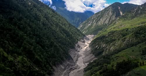
The disaster unfolded with extraordinary speed. A powerful glacial collapse in the Himalayas sent enormous quantities of ice, rock, mud and water rushing into river systems, devastating communities along the Nepal-China border.
The destruction was immense, and the number of dead and missing has continued to rise as rescuers reach areas that were cut off by destroyed roads and bridges. Reuters reported that the flooding was triggered by a glacier collapse and that authorities were also watching newly formed lakes upstream because they could create additional flooding risks.
Now, attention is turning from the immediate rescue operation toward a difficult question about preparedness.
Was there enough warning?
A Disaster That Moved Faster Than People Could React
One of the most challenging aspects of the disaster was its speed.
Early reports indicate that the flood was not simply the result of ordinary heavy rainfall. Instead, a major glacial collapse appears to have triggered a sudden surge of debris and water into downstream valleys.
The force of the event was extraordinary.
Scientists investigating the disaster believe a massive section of glacier and surrounding material collapsed, sending a mixture of ice, rock, mud and water into the river system. The resulting surge caused river levels to rise dramatically in a very short period of time.
For communities living downstream, that creates a particularly difficult warning problem.
Traditional flood forecasting often depends on monitoring rainfall, river levels and known flood-prone areas. But when a huge mass of ice and rock suddenly collapses high in the mountains, the available reaction time can be extremely limited.
Even a sophisticated monitoring system cannot guarantee that residents will receive enough warning if an event happens suddenly and remotely.
Could Satellites Have Helped?
Satellite technology is already playing an important role in understanding what happened.
Authorities have been using satellite imagery to examine the affected mountains and monitor changes in the landscape. Images have also helped officials identify lakes that formed after the collapse.
According to Reuters, one newly formed lake has begun draining, while another larger lake remains a concern because it has no obvious outlet and could continue accumulating water. Authorities are monitoring the situation because another sudden release could create additional flooding downstream.
But satellites have limitations.
They cannot necessarily provide continuous, real-time coverage of every dangerous mountain slope. Cloud cover, image availability and the remoteness of the Himalayas can all make monitoring difficult.
That means satellite images may reveal what has already happened without necessarily giving communities enough advance notice to escape.
The Case for Better Early-Warning Systems
Experts say the disaster highlights the importance of improving early-warning systems across the Himalayas.
Such systems involve much more than simply installing a sensor.
A successful warning network requires monitoring equipment, reliable communications, trained authorities, clear evacuation procedures and communities that know exactly what to do when an alert arrives.
Experts have emphasized that information alone is not enough. Communities must understand the warning and be prepared to act quickly.
That point is particularly important in remote Himalayan settlements.
A warning sent to a government office is useless if it cannot reach residents downstream.
Likewise, a warning received by a village is not enough if people have nowhere safe to go.
A Cross-Border Challenge
Another complication is geography.
The disaster affected areas on both sides of the Nepal-China border. Water and debris do not recognize international boundaries, meaning that an event occurring on one side of the Himalayas can become an emergency on the other side within minutes.
That makes cooperation essential.
Experts have called for stronger cross-border early-warning systems that would allow information about dangerous glacier movements, landslides, lakes and river conditions to be shared rapidly between countries.
Such cooperation could potentially give downstream communities additional time to evacuate.
But building a system capable of operating across some of the world’s most difficult terrain is an enormous challenge.
Climate Change Adds Another Layer of Risk
The disaster has also renewed concerns about the changing Himalayan environment.
The Hindu Kush Himalaya region is warming rapidly, and scientists have warned that rising temperatures can contribute to glacier retreat, permafrost degradation and increasing instability in mountain environments.
As glaciers shrink and landscapes become less stable, hazards can change.
A warming climate does not mean that every individual glacier collapse can automatically be attributed to climate change. Scientists still need to examine specific events carefully.
But experts increasingly warn that climate change is altering the conditions under which Himalayan hazards occur.
That means communities may face risks that were previously considered rare.
The Warning May Come After the Disaster
Perhaps the most painful lesson from the tragedy is that monitoring often improves after disaster strikes.
The current emergency has already prompted authorities to consider installing additional cameras and sensors downstream. Reuters reported that surveillance improvements are being explored, including equipment near the border town of Timure.
Those systems could become extremely valuable in the future.
Sensors could monitor river levels.
Cameras could provide visual confirmation of sudden changes.
Satellite observations could identify changes in glaciers and lakes.
And automated alerts could potentially transmit warnings faster than conventional communication systems.
But technology must be accompanied by preparation.
Residents need evacuation routes.
Emergency workers need training.
Warnings need to be understandable.
And authorities need clear procedures for deciding when an alert should be issued.
A Race Against Time
For families affected by the current disaster, however, these questions are more than an academic debate.
They are about people who had only moments—or perhaps no meaningful warning at all—to escape.
Entire communities have been damaged. Roads and bridges have been destroyed. Rescue teams have struggled to reach isolated areas, while helicopters have become essential for evacuating survivors and delivering supplies.
Meanwhile, authorities remain concerned about additional flooding from unstable lakes and debris blockages.
That means the danger has not necessarily ended simply because the initial torrent has passed.
What Happens Next?
The disaster is likely to become an important case study for scientists, engineers and disaster-management authorities.
Investigators will want to understand exactly when the glacier began failing, how the collapse developed, how quickly the flood traveled downstream and what monitoring information was available at the time.
Those answers could help determine whether earlier detection was realistically possible.
It is important not to assume that technology could have prevented the disaster without examining the evidence.
Some glacial collapses happen so rapidly and in such remote locations that predicting the exact moment of failure may remain extremely difficult.
But there may still be opportunities to improve the system around them.
Even a few minutes of additional warning can sometimes mean the difference between life and death.
A Lesson for the Himalayas
The tragedy in Nepal and Tibet is therefore not only a story about one devastating flood.
It is a warning about a changing mountain environment and the communities living downstream from it.
The Himalayas provide water, livelihoods and economic opportunities to millions of people. But they also contain glaciers, unstable slopes, rivers and lakes capable of producing sudden and destructive hazards.
As climate change alters those environments, the need for better monitoring and preparedness becomes increasingly urgent.
The goal should not simply be to predict every disaster perfectly.
That may be impossible.
The goal should be to make sure that when the next dangerous event begins, communities have the best possible chance to know about it, understand the warning and reach safety.
For the families still searching for loved ones, that lesson comes far too late.
But for the future, it could save lives.